FAMILY WEB PAGE

MAPS
The Scottish sea coasts contain inlets called Firths. These are similar to Scandinavian fjords and exist at the outlet of a river into the sea. Moray Firth is shown below.

Moray
As legend has it, an early king of Pictland named Cruithne (who was a son of Cinq) divided his land amongst his 7 sons, as illustrated on the map, Seven Sons of Cruithne, below. (On this map, just look at the names, because the geographic boundaries refer to a later division of lands.)

Seven Sons of Cruithne
One of those sons was named Fortriu, who received land including what would later be considered Moray. While Fortriu is difficult to date, another son, Fib, is said to have ruled between 715 and 691BC. Some variation exists because the timing for Picts is variously reported as a period starting between the Mid to Late Iron Age (400BC to 250AD) and ending in the Early Medieval period (approximately 900AD).
Kenneth MacAlpin united the Scottish kingdoms in 843AD, and over time, areas of land were re-divided, combined, and re-divided again.
Mormaers were rulers of areas smaller than all of Scotland. Moray remained a mormaerdom until 1130 or 1147, when it was annexed to Scotland, under
King David I.
Malcolm III (reigned 1058 to 1093) appears to have introduced the idea of shires, governed by shire-reeves (sheriffs) as part of a policy of replacing previous forms of government with Norman feudal structures. This policy was continued by Edgar (reigned 1097 to 1107), Alexander I (reigned 1107 to 1124), and in particular David I (reigned 1124 to 1153). For example, Stirlingshire appears in a charter of 1150 under the name Striuelinschire.

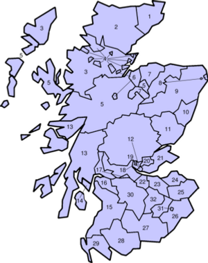
Map of Mormaerdoms
-Moray is located around the Moray Firth. In the middle ages (500 to 1500 AD) it covered nuch of what is now Highland and Aberdeenshire, in addition to the modern council area of Moray.
In 1305 Edward I of England, who had deposed King of Scots John Balliol, issued an Ordinance for the Government of Scotland. This document listed the 23 shires then existing and either appointed new sheriffs or continued heritable sheriffs in office.
Shires Until 1890
18. Stirlingshire
19. Clackmannanshire
20. Kinross-shire
21. Fife
22. Linlithgowshire
24. Haddingtonshire
25. Berwickshire
26. Roxburghshire
27. Dumfriesshire
29. Wigtownshire
30. Lanarkshire
31. Selkirkshire
32. Peeblesshire
Key to Shires Until 1890
-
1. Caithness
-
2. Sutherland
-
3. Ross-shire
-
6. Nairnshire
-
8. Banffshire
-
10. Kincardineshire
-
11. Forfarshire
-
12. Perthshire
-
13. Argyll
-
14. County of Bute
-
15. Ayrshire
-
16. Renfrewshire
-
17. Dunbartonshire
In 1889, counties were created by the Local Government (Scotland) Act which replaced the ancient shires by new Counties (shires), aligned to sheriffdom (shire) boundaries, shown on the map SHIRES from 1890 to 1975.

SHIRES from 1890 to 1975
The 1947 map below includes
-Counties and Districts,
-Cities,
-Large and Small Burghs
For more clarity: Try your View tab and Zoom 150%

In 1975, shires ceased to be used for local government purposes, and local government regions were developed. The area which took in Aberdeenshire, Moray, and the City of Aberdeen was called the Grampian Region. Today, local government is based upon Council Areas. The Council Areas have adopted some shire names but the boundaries are not necessarily the same as the shires were.

Present Day
Council Areas and their Capitals

Present Day Moray

Present Day
Aberdeenshire

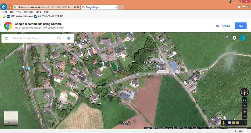
North East Scotland: showing:
-New Pitsligo
-Strichen
-Rathen
-Old Deer and Mintlaw (bottom)
-Fraserburgh (top)
Reference Distance:
Fraserburgh to Mintlaw
is 12 miles (20.1 Km)

Location of Tullibardine, including:
-Scone
-Blair Atholl (location of Blair Castle)
-Stracathro
-Aberdeen
Reference Distance:
Tullibardine to Aberdeen
is 105 miles (169 Km)

Rathen and surroundings.
Note Redhouse and Stonehouse at southwest and southeast of townsite.
More close-up view is below.

South end of Rathen Parish.
Redhouse and Stonehouse are at southwest and southeast of townsite.
Straight north to Tonkin
MAPS of SASKATCHEWAN
The dark blue quarter section was George Murray's homestead
(SE 1/4 20 TP24 Rge 2 W of 2nd), between Saltcoats and Rokeby.


SASKATCHEWAN
Showing, Saltcoats, Rokeby and Yorkton.
George Murray's homestead was between Saltcoats and Rokeby.
NW TERRITORIES
Before Saskatchewan became a province in 1905, Saltcoats was in the district of Assiniboia, in the NW Territories.

SIMMONS and RICHARDS
The Simmons family was from Monmouth, in Monmouthshire, Wales. Thornton was born there. The Richards family was from St Briavels, which is just across the Welsh border in Gloucestershire, England. Louisa was born there.
The red outline is Monmouthshire.


ABOVE:
These places are part of the Simmons family story.
Pin shown on St Briavels, and north to Raglan, Monmouth, Symonds Yat, and Hereford.
Aylburton, not shown is 5 miles east of St Briavels.